

The Basics
- Height: cascades
- GPS: N34 19.168, W93 13.606
- USGS Quad: Baker Springs
- Distance: 0.25+ mile One-Way
- Difficulty: Easy Hike
- Location: Cossatot River State Park
- Region: Arkansas River Valley & Ouachita Mtns
Details & Directions
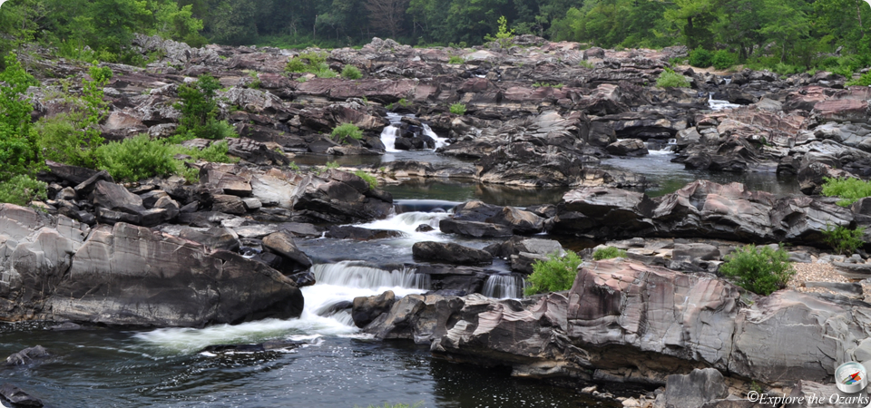
Although just a series of cascades in the middle of a river, this is such a spectacular place to visit. In the past, it has been a mecca for kayak enthusiasts, but the area has more recently become popular for its remoteness and scenic beauty. The name Cossatot means "skull crusher," and gets its name from the class IV - class V rapids during high water. But, during lower water, the cascades create many small drops and falls, and wonderful pools for swimming in the summer.
To get to Cossatot Falls from the park's Visitor Center, travel EAST on US Hwy 278 for 1.3 miles, then turn LEFT onto Weyerhaeuser Rd 52200 (this is just before the bridge over Baker Creek, across the highway from the Harris Creek trailhead). Take 52200 for 3.6 miles, until you come to an intersection with Weyerhaeuser Rd 52600. Turn LEFT and follow 52600 for 1.8 miles, then turn LEFT into the Cossatot Falls Rec Area.
To get a closer view of the falls area, take the trail that leaves from the parking area, across two bridges. After the second bridge, the trail will turn left and head uphill, but we want to KEEP STRAIGHT ahead and follow down along the banks of the river. After so far, it will become a scramble over many boulders and rocks, so just find your way the best you can. Eventually, you can only go so far downstream, before you get blocked by a wall of rocks, and will have to head back.